
Ferguson Fire Related Potential Road Closures
Experts agree that in the aftermath of the Ferguson Fire road closures caused by mudslides and rockslides are inevitable. A team of experts is working to protect public safety while minimizing inconvenience to residents and visitors when these events happen.


To keep the affected communities informed, I asked people from these organizations to talk about their efforts at two community meetings, the first in El Portal occured on October 18th at the Community Hall; the second is scheduled in Midpines on the 24th in the Bodie Room at the Yosemite Bug at 5:30 PM.
The image on the right lists the speakers at the El Portal meeting. We hope to be able to post the PowerPoint slides used by the first two speakers shortly.
Below are audio recording of the various speakers at the El Portal Meeting.
A recording of the audio from Kellen Takanaka's (U.S. Forest Service) talk is available using the controls above. Or watch Kellen's slides with audio here. The audio is not coordinated with the slides so you will need to advance the slides as appropriate with your keyboard cursor keys. If you don't hear the audio, make sure that power saving features of your browser are not blocking this site from playing audio.
A recording of the audio from Greg Stock's (Yosemite National Park) talk is available using the controls above. Or watch Greg's slides with audio here. The audio is not coordinated with the slides so you will need to advance the slides as appropriate with your keyboard cursor keys. If you don't hear the audio, make sure that power saving features of your browser are not blocking this site from playing audio.
A recording of the audio from Kevin Packard's (Mariposa County Office of Emergency Services) talk is available using the controls above.
A recording of the audio from Kris Mattarochia's (National Weather Service) and is available using the controls above.
A recording of the audio from Rick Lindgrin's (CHP) and Chantel Vernon and Jess McCoy from Caltrans' talk is available using the controls above.
A recording of the audio from Sean Jacobs' (School District) and Robin Smith's (NRCS) talk and discussion after various talks is available using the controls above.
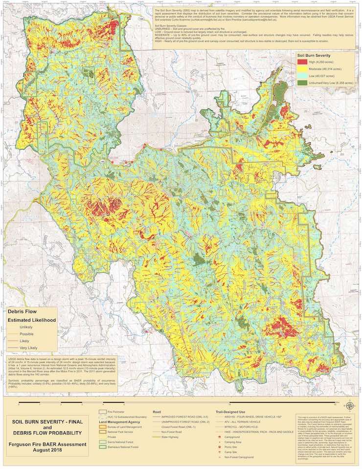
Also of interest is the Soil Burn Severity and Debris Flow Probability map (above) developed by the Burned Area Emergency Response (BAER) team. This map predicts where debris and flooding are likely to occur and, based on the recent rain event, it seems to be remarkably accurate! Click here for a high-resolution (12 MB) pdf of the Burn Severity map.